Imagine, if you will, a transportation map. Any map will do. It could be a road map, a bus map, a train map, or even just a centralized map of the leading commercial area of any particular city. It could be that old, raggedy Rand McNally atlas that has been unnecessarily taking up space in the back of your family’s station wagon for who knows how many years. It could be the subway map that you hastily picked up on your way out of the Amtrak station during your last train-based vacation. It could even just be your cell phone. After all,, that ubiquitous marvel of modern technology has become the de facto replacement for ink and paper maps all over the world. Just create a mental image of any network of transport pathways.
Regardless of which medium of navigation you ended up thinking of , what was one thing that all of them — every single one of them — had in common?
They all centered around —or at least featured — central routes, or lines that served as the primary avenues through which people went around their respective cities or countries and went about their daily activities. Whether they were traveling to their workplaces, running errands, visiting friends or family, or even just going to the movies or the museum, people always had to use some form of public or private transportation, on a mixture of road, rail, and river, in addition to walking.
Every city has some significant thoroughfare through which these transportation systems operate. New York has Broadway, the West Side Highway, and the FDR Drive. San Francisco has the Embarcadero. Washington, D.C. has the Capital Beltway. And while it’s a relatively smaller and lesser-known city than the above examples, Rochester has the Inner Loop.
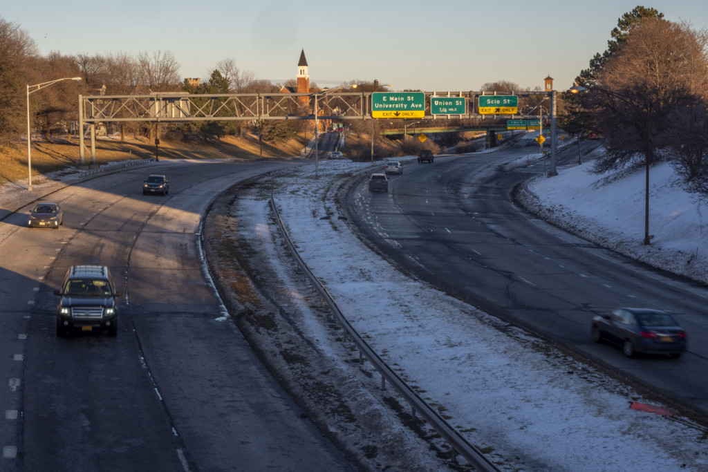
For public transportation, the city known for flowers and flour primarily utilizes a bus system, which replaced the old subway system that used to run until the 1950s. However, one of the main, and indeed most infamous, roadways still in operation within the city is the Inner Loop (shown below), a freeway in downtown Rochester whose official track consists of a loop around the city’s downtown Central Business District. A portion of the Inner Loop also made up a part of Interstate 490 before branching eastward from the road toward the city’s downtown area. At the time of the Inner Loop’s construction, roughly 70 years ago, the population of the city and the popularity of the automobile were significantly expanding. Leading up to the eventual construction, traffic congestion became increasingly challenging to manage. In an effort to relieve that congestion, the city of Rochester dug a deep trench for this highway bypass, which was meant to speed residents out of the central city and into its suburbs.
However, getting people in and out of Rochester was an idea that wasn’t popular on a universal scale. The construction of the loop even led to white flight from the central areas of the city. During the late 1950s, when the Inner Loop and Interstate 490 were being built, white citizens of Rochester had already begun the process of moving out toward the city’s suburbs. However, after the race riots of 1964, white Rochesterians rapidly relocated to the suburbs, taking their businesses and property tax revenue with them. This fallout disproportionately affected minorities who didn’t have the same amount of income to leave Rochester.
However, many long years later, upon first glance, the loop is nowhere near the outstanding success or miraculous child of modern transportation urban planners made it out to be in the early 1950s. Not even close.
The problems with this highway started even before construction began. According to Tom Hack, the former Chief Structural Engineer and Managing Engineer/Constructor for the city of Rochester, there was intense disapproval and opposition toward the project coming from the South Wedge neighborhood of the city. “These residents did not want the road coming right through the heart of the neighborhood,” Hack said. “They were apprehensive about the fact that if the Inner Loop were to be constructed as planned, it would result in the demolition of dozens upon dozens of houses that made up this incredible locality.”
Another major issue with this roadway was that rather than being a raised highway, as most major roads have been constructed for quite some time, the Inner Loop was built as a fully sunken road surrounding the city’s downtown area. Hack had this to say about the infamy of the Loop and its issues: “In every sense of the term, the Inner Loop has become a moat of asphalt. From the minute you cross the loop, you knew you were in a separate area of the city. You could immediately tell when you were in the city’s Central Business District and when you were in a more residential area.” This visual dichotomy between the downtown and residential areas of Rochester didn’t do anything to help enhance the city’s intended public image as a tourist-friendly city. Additionally, as the use of the road started to drop off, the number of professionals who looked after the road began to diminish rapidly, and the road quickly fell into disrepair.
The Inner Loop was hardly the kind of gateway feature that one often sees in most major cities. A sunken highway doesn’t tend to be the image that most cities put on their postcards. For tourists hoping to explore the city’s other, more aesthetically pleasing highlights, particularly the Central Business District, High Falls, Eastman Kodak Tower, and other destinations, they would have to bear witness to this neglected highway, which could be incredibly off-putting.
As time has marched on, the Inner Loop proved to be not much more than a simply colossal boondoggle for Rochester. The road has only seen minimal traffic, but it has also done nothing to enhance the city’s image. It has made it more arduous to use alternate modes of transportation, and it has essentially separated neighborhoods from the Flower City’s downtown. All in all, the road has proven itself time and time again to be a pretty sizable burden for the city, and it doesn’t seem like the overall public opinion toward it will become anything close to enthusiastic any time soon.
Even with all of its shortcomings, the Inner Loop is not the first case of a controversial roadway in the state of New York. The Cross Bronx Expressway has also spent a solid portion of its lifetime in scrutiny. The first highway built through a crowded environment in the United States is located in the Bronx, the northernmost borough of New York City. This highway was the brainchild of Robert Moses, perhaps one of the most famous urban planners in the history of American metropolitan areas. While the road serves as a thoroughfare between the boroughs of Manhattan, the Bronx, and Queens, some controversy is attributed to it that is oddly similar to that of the Inner Loop.
The Cross Bronx Expressway goes across the Bronx in a relatively straight horizontal line. While the Inner Loop was obviously never a linear road, the construction of this NYC expressway was essentially blamed for roughly dividing the borough in half. According to Phillipe Martin Chatelain, the creation of this contentious highway caused a relocation of middle- and upper-class Bronxites to northern areas of the borough, leaving the south Bronx to become a neglected neighborhood where the majority of the residents have unfortunately low incomes. Like the Inner Loop, the Cross Bronx Expressway essentially became a modern moat that ultimately did nothing to contribute to any anticipated economic boom.
Residents from all over Rochester and its many suburbs have their own points of view regarding the Inner Loop, and almost all of them lack any feeling of positivity toward the highway. Junior Jacob Ritterman, a lifelong resident of the Rochester suburb of Penfield, has been driving around Monroe County for just about as long as he’s been able to drive, frequently traveling through the main areas of Rochester. From the moment he received his driver’s license, Ritterman has made a routine out of going for drives of varying times and distances every single day, even if he has nowhere to go.
Sometimes he goes on drives to local businesses, sometimes to nearby parks, or recreation areas. Every now and then, he even wanders for 20 to 30 minutes, aimlessly motoring on to wherever he feels like. However, there’s one highway in particular that even this Rochesterian makes sure to steer clear of.
He rarely ever uses the Inner Loop during his travels. “I don’t know a single person who uses the Loop to get somewhere,” Ritterman says. “In fact, everyone I know actively goes out of their way to avoid using the road.”
Nowadays, it’s essentially a near-ghost road. It’s an abandoned roadway. It’s an eyesore. On top of all of that, in perhaps the most prominent sign of the road’s flaws and failures, it’s no longer even a loop.
As it turns out, the Inner Loop is in the process of being more or less filled in. As mentioned above, the roadway is less so in the shape of a loop but more so in the form of a letter “C,” as the eastern section of the road has been filled in. According to a New York Times article from 2016 covering the beginning of this process, Rochester Mayor Lovely Warren said that filling in the loop “gives people the ability to more easily get around, and gives [the city] more space to develop.” The mayor also talked about the fact that there was so much interest from housing and retail projects in space left by the old eastern section of the loop that she pushed the city council to begin the next great project, which included filling in the north section of the loop, where a large portion of Rochester’s concentrated poverty is located. “Connecting the northern part of the city with downtown creates opportunity,” Warren said. This connection ultimately makes it easier for the city’s economic engine to expand outward from downtown to worse-off areas, potentially revitalizing Rochester on all facets.
The Inner Loop was indeed a moat around Rochester. A barrier that prohibited the city from having a cohesive feel to it. According to that same New York Times article, the project of removing the highway has already produced significant results for the city’s economy. A local developer, Home Leasing, was able to complete “about 70 market-rate apartments on a long-vacant four-acre lot on the west side of the old loop.” The economic benefits started to make appearances merely a couple of years following the beginning of the erasure of the Inner Loop, and the fact that this turnaround was so quick speaks to the fact that the road has truly done nothing to help the city.
Even though there have been tons and tons of controversial and harmful roads around the world and throughout history, the Inner Loop of Rochester is a true cautionary tale to urban planners everywhere about how one road can cause a myriad of problems in the long run.

